
Subsurface Utility Engineering (SUE)
A New Standard In Damage Prevention
By providing subsurface utility location services we have developed a new standard in damage prevention. By using a combination of different equipment including Ground Penetrating Radar (GPR), Electromagnetic Locators and Detectable Sondes and Rodders, our teams not only comply with national industry standards and, are trained in theory and practice of applying subsurface interface radar in engineering and geophysical investigations but, have been revolutionizing the process from bringing their findings in the field into a survey grade digital format that is compatible with almost any CAD program or need. We combine this with our years of surveying experience and top of the line equipment to give our clients SUE grade B data that can be upgraded to level A in certain situations if needed.
By bringing private utility locations in house we have eliminated the loss of information as it passes through multiple hands and developed the premier private utility location service that has the capability of handling everything from single line locates to entire manufacturing plants and energy projects. We have the professional staff and resources to maintain continuity on any given project by delivering a quality project on schedule to meet milestones to satisfy the engineers, developers and contractors, and still maintain the highest quality of information and accuracy throughout the life of the project.
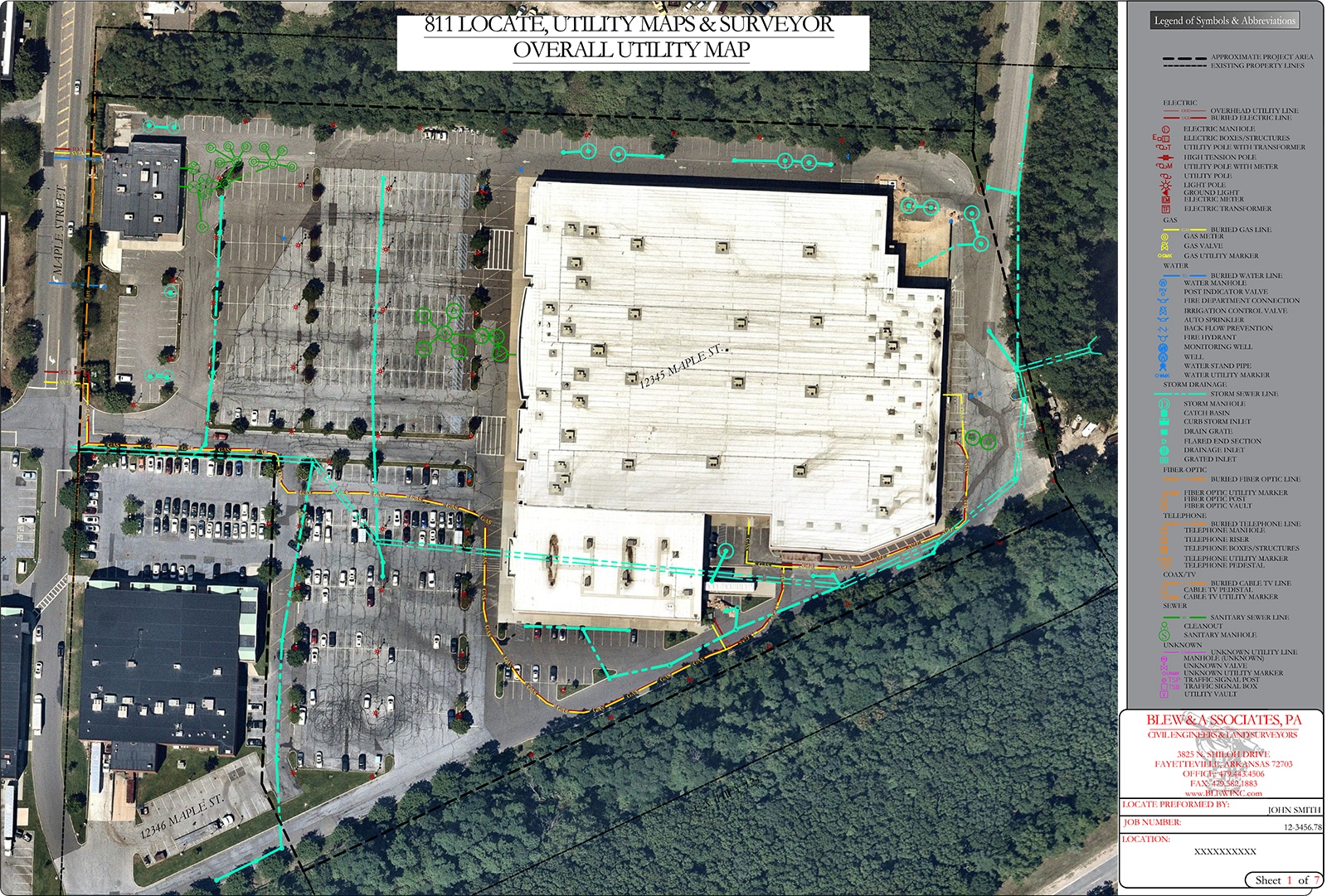
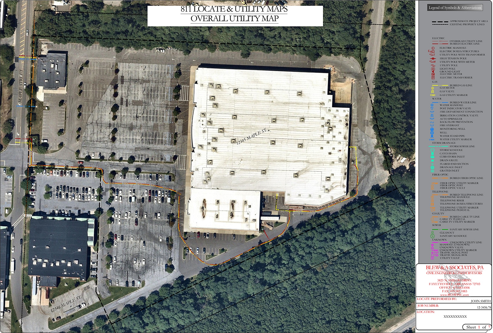
Commercial Demo Description
Shown here is a commercial shopping center. In preplanning the field locator was unable to find any documentation of the local sewer and storm water system. Upon arriving the locator quickly realized that all buildings located within the property used septic tanks and were not connected to public sewer. The locator then used GPR to map the tanks in order to create an accurate utility map.

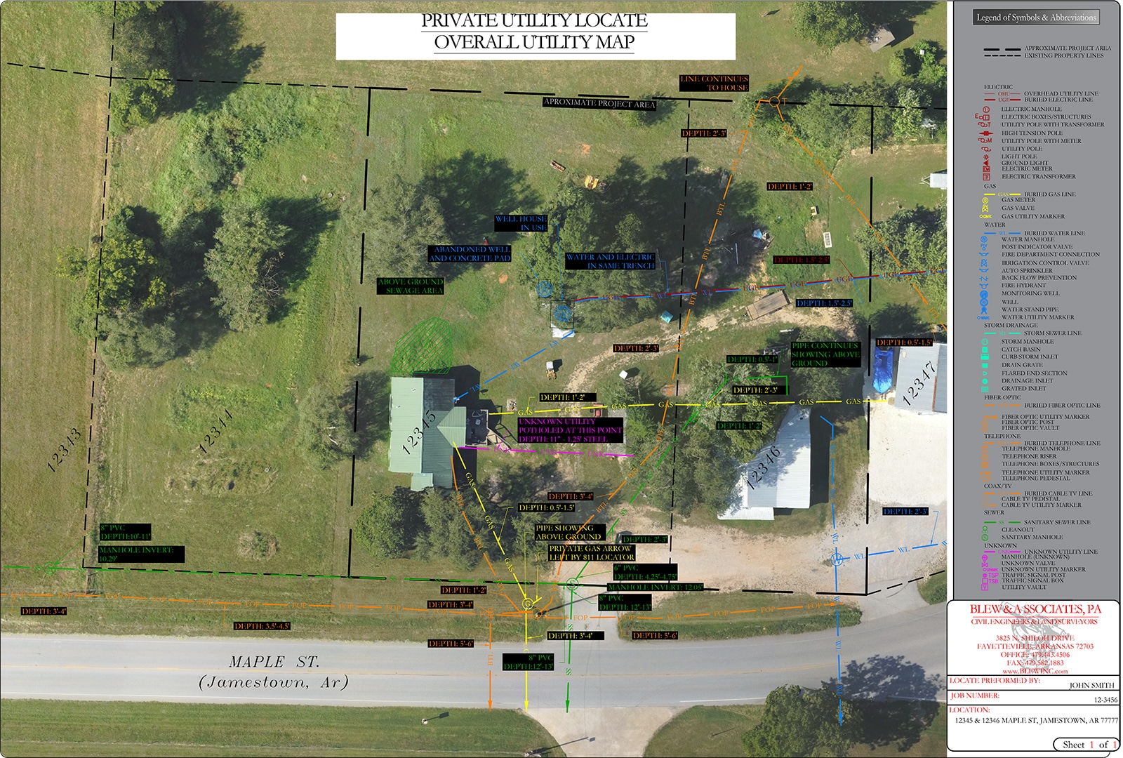
Residential Demo Description
Shown is a residence that was to be condemned and replaced with a new structure. The property it is on originally a part of a larger portion of land with 3 residences. As you can see some of the utilities present are running to multiple residences and if the project were to take place without having knowledge of this several issues would arise. Thankfully all lines were located through our private utility locate service and our clients were able plan for these issues before starting construction.

Statement Of Qualifications
We give our clients, the best chance of success and have developed a new standard in damage prevention. By using a combination of different equipment including Ground Penetrating Radar (GPR), Electromagnetic Locators and Detectable Sondes and Rodders, our teams not only comply with national industry standards and, are trained in theory and practice of applying subsurface interface radar in engineering and geophysical investigations but, have been revolutionizing the process from bringing their findings in the field into a survey grade digital format that is compatible with almost any CAD program or need. We combine this with our years of surveying experience and top of the line equipment to give our clients SUE grade B data that can be upgraded to level A in certain situations if needed.
By bringing private utility locations in house we have eliminated the loss of information as it passes through multiple hands and developed the premier private utility location service that has the capability of handling everything from single line locates to entire manufacturing plants and energy projects. We have the professional staff and resources to maintain continuity on any given project by delivering a quality project on schedule to meet milestones to satisfy the engineers, developers and contractors, and still maintain the highest quality of information and accuracy throughout the life of the project.
Defining Subsurface Utility Engineering
Subsurface Utility Engineering (SUE) is the process of identifying underground infrastructure through nondestructive methods. While this may sound similar to private utility location since in the field they look almost identical (Both use various technologies in order to mark utilities with flagging and paint). The key difference between the two is that Subsurface Utility Engineering extends far beyond Private Utility Location in that the technicians are much more accurate in recording the findings and are capable if inserting them into a variety of different CAD and GIS applications in order to create accurate design plans and as-builts. SUE is an engineering practice that has evolved considerably over the past few decades. The SUE process combines civil engineering, surveying, and geophysics. It utilizes several technologies, including vacuum excavation and surface geophysics. Private Utility location primarily involves marking utilities with paint on the ground in active construction sites and home renovations and typically is not recorded with anywhere near the accuracy of SUE. Our teams typically provide quality level B utility information although in curtain situations can provide quality A if needed.
SUE Quality Standards
Quality levels may be thought of as degrees of risk, or how much information is really needed to adequately design and construct a highway project. Highway plans typically contain disclaimers as to the accuracy of the utility information. The use of quality levels allows project owners to decide what quality level of information they want to apply to their risk management challenge and to certify on project plans that a certain level of accuracy and comprehensiveness has been provided.
There are four recognized quality levels of underground utility information ranging from Quality Level (QL) D (the lowest level) to Quality Level A (the highest level). The highest level of accuracy and comprehensiveness is generally not needed at every point along a utility’s path, only where conflicts with highway design features are most likely to occur. Hence, lesser levels of information may be appropriate at points where fewer conflicts or no conflicts are expected.
Each of the four quality levels is described as follows:
- Quality Level D. QL-D is the most basic level of information for utility locations. It comes solely from existing utility records or verbal recollections, both typically unreliable sources. It may provide an overall “feel” for the congestion of utilities, but is often highly limited in terms of comprehensiveness and accuracy. QL-D is useful primarily for project planning and route selection activities.
- Quality Level C. QL-C is probably the most commonly used level of information. It involves surveying visible utility facilities (e.g., manholes, valve boxes, etc.) and correlating this information with existing utility records (QL-D information). When using this information, it is not unusual to find that many underground utilities have been either omitted or erroneously plotted. Its usefulness, therefore, is primarily on rural projects where utilities are not prevalent, or are not too expensive to repair or relocate.
- Quality Level B. QL-B involves the application of appropriate surface geophysical methods to determine the existence and horizontal position of virtually all utilities within the project limits. This activity is called “designating”. The information obtained in this manner is surveyed to project control. It addresses problems caused by inaccurate utility records, abandoned or unrecorded facilities, and lost references. The proper selection and application of surface geophysical techniques for achieving QL-B data is critical. Information provided by QL-B can enable the accomplishment of preliminary engineering goals. Decisions regarding location of storm drainage systems, footers, foundations and other design features can be made to successfully avoid conflicts with existing utilities. Slight adjustments in design can produce substantial cost savings by eliminating utility relocations.
- Quality Level A. QL-A, is the highest level of accuracy presently available and involves the full use of the subsurface utility engineering services. It provides information for the precise plan and profile mapping of underground utilities through the nondestructive exposure of underground utilities, and also provides the type, size, condition, material and other characteristics of underground feature.
Accurate & Comprehensive Field Data
At Blew & Associates we understand better than most the importance of accurate and comprehensive field data. Through our over 100 years of business we have watched as underground infrastructure has become a more and more prominent part of the construction planning, engineering, and surveying industry. In order to give our clients, the best chance of success and to develop a new standard in damage prevention we have developed our own private utility location team. Our teams not only comply with national industry standards and, are trained in theory and practice of applying subsurface interface radar in engineering and geophysical investigations but, have been revolutionizing the process from bringing their findings in the field into a survey grade digital format that is compatible with almost any program or need. We combine this with our years of surveying experience and top of the line equipment to give our clients SUE grade B data that can be upgraded to level A in certain situations if needed.
There are more than 100 billion feet of underground utilities in the United States, according to data compiled by Common Ground Alliance (CGA) from various industry groups. Of this, more than 50% is made up of private utilities. So whenever a facility owner or engineer decides to take a dive into the subsurface they are taking a step into the unknown and, due to the rise in awareness of damage prevention from 811 marketing, many owners and engineers are aware of this fact. But, in reality, it can still be very unclear how to navigate the task of safe excavation with so much underground infrastructure.
In 2016 the CGA Estimated that “The societal costs associated with underground facility damages in the U.S. in 2016 are estimated at $1.5 billion. This is a minimum estimate based on routine costs for stakeholders directly connected to a damaged facility. It does not include costs such as property damage, evacuations, road closures, environmental impacts, lawsuits, injuries, and fatalities.” and that there were an estimated 509,000 utility damages in 2018 alone.
- https://commongroundalliance.com/sites/default/files/publications/DIRT%202016%20Annual%20Report_081017_FINAL_08.11.17_0.pdf
- https://commongroundalliance.com/Portals/0/Library/2020/DIRT%20Reports/2018%20DIRT%20Report%20Final_100419.pdf?ver=2020-08-12-025832-050
811 is a great tool and the first step to avoiding safety hazards and costly repairs due to utility damages and, should always be called before any excavation is performed. But, is this enough? In our experience NO. 811 notifies the utility owners within your proposed excavation area. These companies then use their existing records in order to determine whether your excavation area contains any of their underground facilities. The problem with this is that sometimes records can be inaccurate and some of these lines may slip through the cracks. In the event that they do show a utility within your excavation area a field locator will be dispatched to locate the line. Utility field locators are typically well trained and quick to respond but have a limited scope of work, limited equipment, and an exceedingly high demand for their services. They also are only responsible for locating public utilities. While this is a great tool it has its limitations and we believe it is just the first step. Public lines are owned and maintained by utilities and are located to the “point of service” or “dissemination point.” Each utility company determines where their service ends. Also, utility locators typically exclusively use Electromagnetic Locators. While these are great tools for the industry, they only can detect metallic utilities.
In order to get a complete view of the utilities present for your project and, move forward with confidence, it is likely you will need the services of one of our private utility location teams. Our teams will not only locate the private utility lines typically overlooked by 811 services but locate all public and private lines within a project area and document the findings with survey grade accuracy. Our locators have completed locates across the country from small 1 acre vacant lots to large distribution centers and shopping malls and, use an array of utility location tools including Electromagnetic locators, Ground Penetrating Radar and Locating Sondes, along with all provided utility information in order to provide a comprehensive location service so that our customers can complete there projects as safely and cost effectively as possible. We can even provide approximate depths in certain conditions.
Don’t take it from us though. Shown below are some real world examples of just how much can be hiding below the surface and how little of it is usually brought to light by standard procedures.
Blew & Associates: Safety Isn’t Optional
![]() At Blew & Associates the safety and success of our field technicians is our top priority throughout every aspect of our work day and, every team member does their share in order help. All technicians are trained in hazard recognition from the first day in the field and then continue to learn every day whether it be from formal education or advice from a toolbox meeting. Their goal is to provide you with the best results and the smoothest operations in the industry.
At Blew & Associates the safety and success of our field technicians is our top priority throughout every aspect of our work day and, every team member does their share in order help. All technicians are trained in hazard recognition from the first day in the field and then continue to learn every day whether it be from formal education or advice from a toolbox meeting. Their goal is to provide you with the best results and the smoothest operations in the industry.
- First Aid & CPR – Completed by all Utility Locate Technicians
- OSHA 30 – Completed by all Project Managers
- All project managers are trained in Post Processing of GPR data for the purposes of Engineering and Geophysical investigations
- Blew & Associates is a proud member of NULCA and applies best practices to all in house training.
- PACP/LACP/MACP
- Blew has a NUCLA accredited trainer on staff full time for both electromagnetic locating as well as ground penetrating radar and requires all field technicians to complete a robust training program and certification process before entering the field
